| Date | Location | Start Times | Courses | Cost |
| 29 Mar | Raccoon Creek S.P., Rec Hall | Check-in 8:00; Start 10 am Special Pricing1 | 3-hour and 6-hour mini-rogaine with mass start | $18 per person |
If you are planning to come to this event, please preregister at
http://www.wpoc.org/preregistration.php
Preregistration does not involve paying any money until you come to the event. Also, the cost is waived for preregistered kids; so they are free*.
*Anyone who is NOT preregistered (including kids) pays $1 more than the normal cost and is NOT guaranteed a preprinted map. Each preregistered person/group is guaranteed one preprinted map. If a group wants multiple maps, it should preregister in pieces.
If you would like to find out more, go to our Web site www.wpoc.org
Or call Jim Wolfe at 814 255-6606 or e-mail jlwolfe@atlanticbb.net

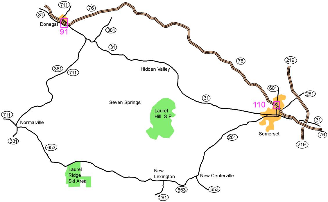
From Donegal,
PA Turnpike exit 91:
Take Route 31 East and 711 South 2.5 miles. Turn right onto
711
South and 381 South. Go 9.6 miles to Normalville; there turn
left
onto 381 South. Go for 0.2 miles; then turn left onto 653
East.
Follow 653 East for 5.7 miles to Laurel Ridge Ski Area.
From Connellsville:
Take Route 711 East for 8 miles to Normalville. Then proceed
as above onto 381 South.
From Somerset, PA Turnpike exit 110:
Take Route 601 South (Center Ave) to Routes 281 South and 31
West
(Main Street). Turn right onto Main St and go until
Route
281 South splits off to the left. Continue on Route 281 South
for
7.7 miles to New Centerville where 281 South merges with Route 653
West. Follow 281 South and 653 West 2.9 miles to New
Lexington.
There bear right onto 653 West and go 7.6 miles to the Laurel
Ridge Ski Area.
From Route 219 east of Somerset:
Take the exit for Route 31 West or Route 281 South and follow them
until they merge (on Main Street). Then, follow the
directions
for Somerset above.
Here is a Google maps link to the Ski Area entrance
The GPS coordinates are 39.955277 N, 79.369863 W