| Date | Location | Start Times | Courses | Cost |
| 27 Oct | Laurel Hill State Park, Trent Pavilion | 11 am to 2 pm This is a new starting location. | Beginner; Novice; Intermediate; Advanced short and long + Bike-O | $6 per map* |
If you are planning to come to this event, please preregister at
http://www.wpoc.org/preregistration.php
Preregistration does not involve paying any money until you come to the event. Also, the cost is waived for preregistered kids; so they are free*.
*Anyone who is NOT preregistered (including kids) pays $1 more than the normal cost and is NOT guaranteed a preprinted map. Each preregistered person/group is guaranteed one preprinted map. If a group wants multiple maps, it should preregister in pieces.
If you would like to find out more, go to our Web site www.wpoc.org
Or call Jim Wolfe at 814 255-6606 or e-mail jlwolfe@atlanticbb.net
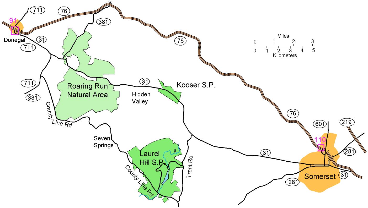
From route 219 east of Somerset:
Take the exit for 281 South. Follow
that for 1.7 miles to a traffic signal where 281 zigs to the left.
Turn left and go for about 0.25 miles to where 281 South zags to the right
and joins with 31 West (at the next traffic signal); there turn right.
Follow 281/31 through Somerset (stay in the right lane) for 1.3 miles to
where 281 and 31 split. Stay with 31 West for 6.6 miles until you
reach Trent Rd, there turn left. Go 3.7 miles to County Line Rd and turn right.
Go for 1.4 miles to the entrance to the Trent Pavilion on the left. Then follow the red and white orienteering
signs to parking.
From the PA Turnpike, exit 110 at Somerset:
From the exit, go south on route 601 into
downtown Somerset were route 31 crosses. Turn right on 281 South/31
West and go for 0.8 miles to where 281 and 31 split. Stay with 31
West for 6.6 miles until you reach Trent Rd, there turn left. Go 3.7 miles to County Line Rd and turn right.
Go for 1.4 miles to the entrance to the Trent Pavilion on the left. Then
follow the red and white orienteering signs to parking.
From the PA Turnpike, exit 91 at Donegal:
Follow route 711 South to route 31 East.
Go on route 31 East 11.4 miles to Trent Rd, there turn right. Go 3.7 miles to County Line Rd and turn right.
Go for 1.4 miles to the entrance to the Trent Pavilion on the left. Then
follow the red and white orienteering signs to parking.
From route 30 at Ligonier:
Follow route 30 East for 2 miles to route
381 South, there turn right. Follow route 381 South for about 12
miles to route 31. Turn left onto route 31 East and go for 8.8 miles
to Trent Rd, there turn right. Go 3.7 miles to County Line Rd and turn right.
Go for 1.4 miles to the entrance to the Trent Pavilion on the left. Then follow the red and white orienteering
signs to parking.
Alternative: From route 30, take
route 711 South to Donegal; then follow the directions for PA Turnpike
exit 91.
Note: For all of these directions, you will pass the main entrance to Laurel Hill while on Trent Rd. You can also reach the
Trent Pavilion by entering the main entrance and following a long winding road over to County Line Rd.
Here is a Goodle maps link to the Trent Pavilion.
The GPS coordinates are 39.984797 N, 79.248793 W